MuniMe
Helps you find the fastest way to get where you're going
in San Francisco.
Helps you find the fastest way to get where you're going
in San Francisco.
In San Francisco, sometimes it doesn't matter which of the 7-or-so lines in walking distance you take to go downtown. But when there are significant delays on one or more lines, you could get stuck waiting for hours.
But sitting down and comparing predictions for all of the nearby stops takes time that you probably don't have on the way to work.
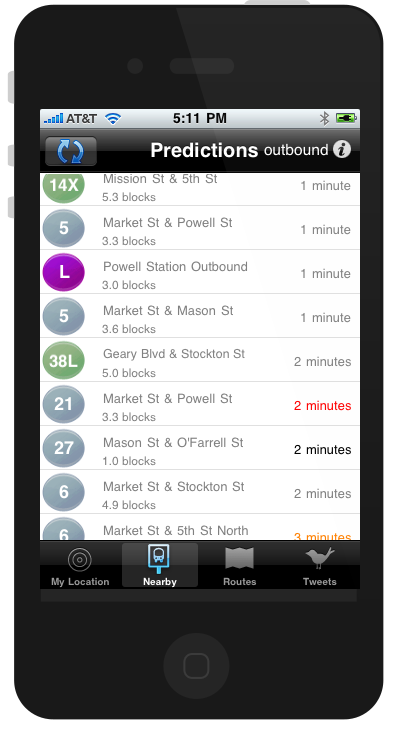
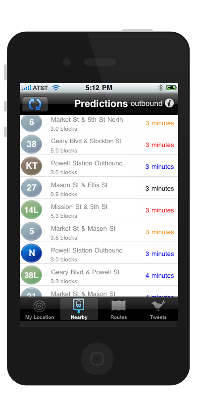
MuniMe uses your current location to provide you with a list of arrival predictions for all of the stops within walking distance, so one click allows you to find which route will put you at your destination first.
MuniMe’s Nearby view shows predictions for arrivals at all the stops near you. You can even customize the number of blocks you’re willing to walk to a stop.
MuniMe gets your current location and provides you with a list of arrival predictions for all of the stops near you so you can quickly find the route that will take you where you need to go soonest.
MuniMe even calculates how quickly you need to hurry to get to the stop on time: the predicted arrival times are color-coded to let you know if you have time for a cup of coffee, or if you need to run in order to make it in time:
run
speed-walk
brisk pace
walk
time for coffee
teleporter required
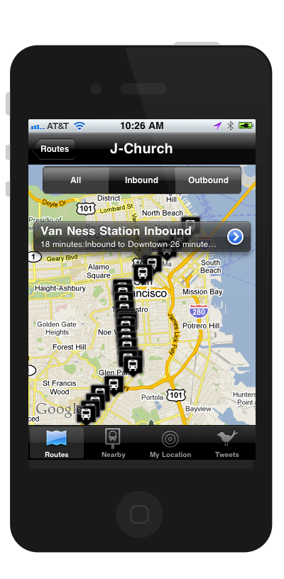
If you’re in an unfamiliar location, click through to view the stop, along with your current location and the location of the bus on the map.
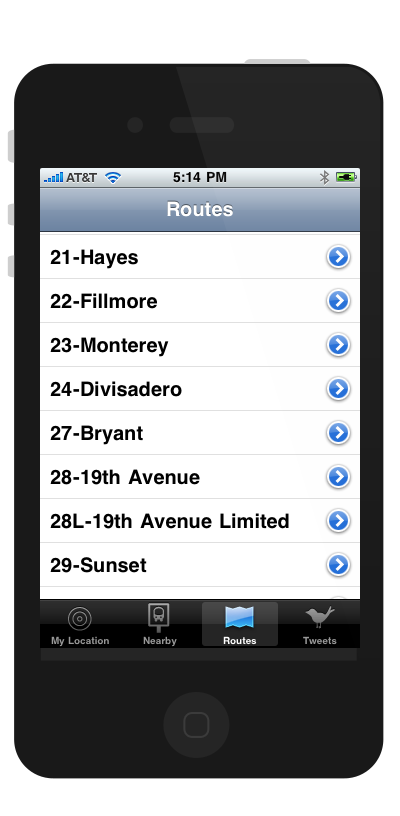
Find predictions for specific lines
When you already know what route you need to take:
And if you aren’t quite sure if a route ends up near your destination, MuniMe can help too: just use the map to see if any stops on the line comes close enough to your destination.
MuniMe was a project that was born out of personal necessity. Living in part of the city where one can easily take 4 bus lines within a 2 block radius, and about 8 more lines within a 15 minute walk, a commute that takes 15 minutes by bike should not take more than an hour when using public transportation.
Due to snafus that occur almost daily - from accidents on surface streets to construction to tourists accidentally driving into the subway tunnels - MUNI is far from the most reliable public transportation in the nation.
But the ability to rely on public transport was one of the reasons I fell in love with San Francisco, so I wasn't going to let delays stop me from being a champion for public transport. (I wrote a book about BART when I was 5. Seriously. I wrote it myself... see the photographic evidence below)
MuniMe typically saved users 2-3 hours a week in time spent waiting for public transport.
Although I'd done many cross-platform and web apps for mobile, this was both my first native iOS app and my first real foray into vector art.
This was a personal project, so excepting bugs, few updates were made, and there were no resources available to invest in formal usability studies, but the real metric for success of this app is its functionality.
On average, my friends and I found that using MuniMe saved around 2-3 hours a week in time spent waiting for public transport, sometimes more... and allowed us to save a significant chunk of money on cab fare when a ghost bus rolled past, after waiting 2 hours for a bus that never came, and to keep us from having to wait somewhere we felt unsafe when there was a weird guy hanging around the bus stop.
UX work product for this project is currently in storage; the app is not available in the App Store at this time.
Some of the screenshots here are from earlier versions, reflected in the inconsistencies in visual design.
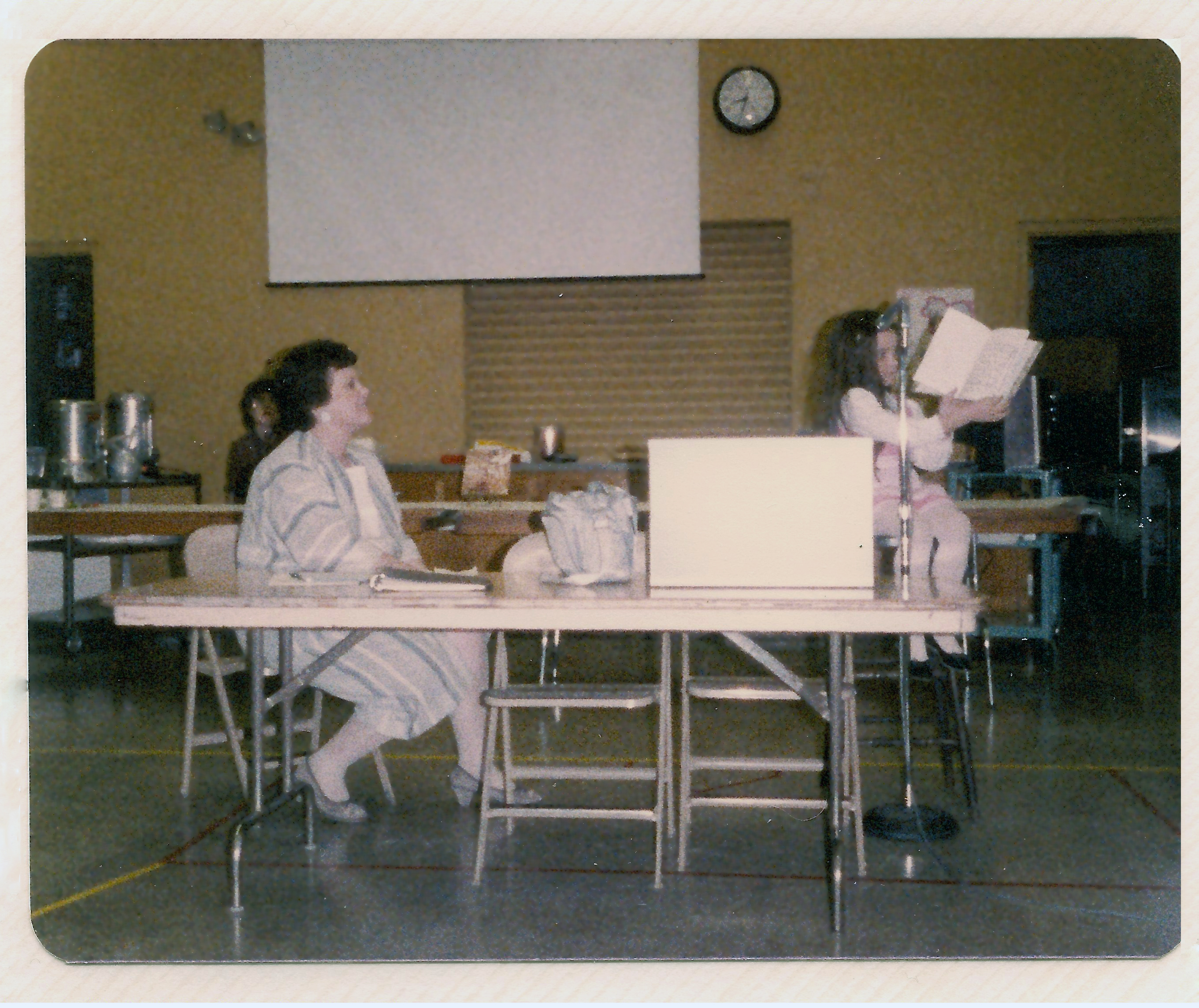
Me, reading the book I wrote about BART when I was in kindergarten in front of the school board.
Want to know what’s going on?
View the latest muni-related tweets, and post your own inside the app.
Curious as to why there won’t be an N-Judah for another 36 minutes?
MuniMe displays the most recent Muni-related tweets so that your fellow Muni riders can alert you toany potential problems on your way, helping you avoid any routes that might slow you down.
And in the event you forgot your reading material, Muni-related tweets provide a colorful distraction while en route.
Need to vent?
or report a driver for shutting the door on someone’s head.
Share that info with your fellow riders by posting twitter updates without leaving MuniMe.
Your tweets are automatically tagged with #muniMe #sfMuni… and you decide if it’s a #munifail or #muniftw.
Doing the legwork for you, MuniMe is a vital tool for any daily commuter, helping you save an average of 15-20 minutes each day. At this time, MuniMe is most useful for the daily commuter who is somewhat familiar with the Muni system.
Since predicted arrival times can change drastically within the time it takes to get from one point to a transfer point, MuniMe does not provide point-to-point directions at this time. As we continue to collect data on the reliability of predictions for various routes, MuniMe will have the information it needs to provide the best predictions for routes to a specific destination.